Executive Summary
The following pages will give you an introduction to MAEviz. First, we will start with a short description of the layout of the program which will help you get familiar with the work environment before you start using MAEviz. We will follow that with a tutorial where you'll be able to run an earthquake risk assessment analysis. The purpose of this tutorial is to help you feel comfortable using the program and to also give you a clear idea of what MAEviz can do. The last part covers a user's guide where you can find a more extensive explanation of MAEviz capabilities that were not covered on the tutorial.
Exercise Overview
MAEviz Overview
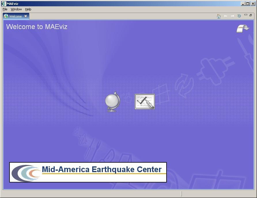
Welcome
When MAEviz is first launched, the welcome screen appears. From the welcome screen, users can select to read an overview of information about MAEviz, follow built-in tutorials, or just begin working in MAEviz (by selecting Workbench which will take you to the main MAEviz screen, also known as the Workbench). See figure above.
Workbench Layout
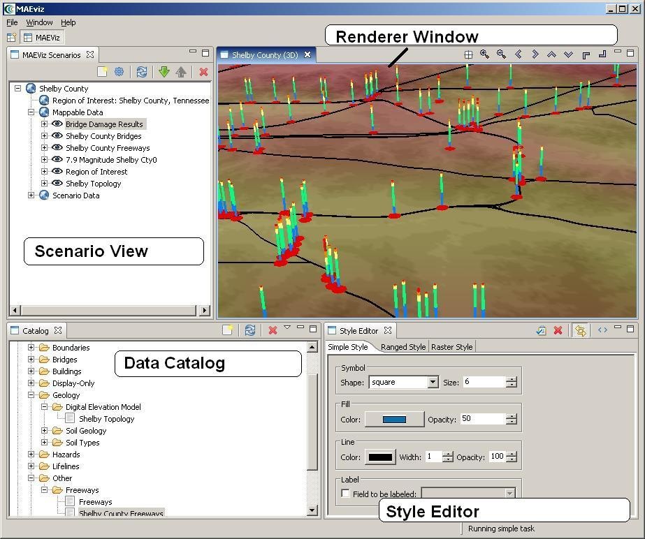
The MAEviz workbench consists of a number of Views, each containing information about a specific part of MAEviz. Each view is like a sub-window within the MAEviz workbench window, and can be minimized, maximized, moved, or even torn away from the main window into its own window. These interactions are done by clicking the minimize and maximize view icons in the view's title bar, or by clicking and dragging on the view's border or title bar.
See the image below for the most commonly used views in MAEviz.
Scenario View
The Scenario View is where you will find a list of all the data for the scenario or scenarios that you are currently working with. Each scenario that you are working with is listed as a top-level item in this view, which can be expanded by clicking the plus icon next to its name, to see the details of the scenario. Inside each scenario, you can see a list of the Mappable Data and Scenario Data. All data listed in Mappable Data are the layers of data that appear in your rendered map whereas all the data listed in the Scenario Data includes all non-renderable data for the scenario (e.g. tables).
The Scenario View is also where you would go to do the major operations on your scenarios: adding an earthquake hazard or other data, running damage analyses, etc.
Visualization View
The Visualization Window Views are where the rendered maps of your scenario will appear. Each scenario can have its own rendered 2d and 3d map, so you can see the visualization multiple scenarios simultaneously if desired. It is here that you can get a quick visual overview of the results of your analyses. You can control the camera position by using the mouse, or click the view control buttons in the toolbar.
Data Catalog View
The Catalog View is a list of all the data that is available for you to use in your scenarios. It is organized first by repositories, which are stores of MAEviz data. Repositories can represent local data, or data stored on a remote server. Within each repository, the data is organized by the type of data that it is. To add data to a scenario, you can navigate to and find the data within this view, then drag it into either the Visualization View for your scenario, or onto the scenario's name in the Scenario View. Before data can be made available to your scenario, it must be ingested into a repository and assigned a type. You can find instructions on ingesting building data here.
Style Editor View
The Style Editor is used to adjust the way in which a layer of data is displayed in the Visualization View. If the Style Editor is not visible, you can show it by right clicking a Mappable Data layer in the Scenario View, and selecting Change Layer Style. Once this view is showing, you can adjust the color, shape, opacity, and other display characteristics of the map layer. To apply your style changes, you must click the Apply button ( ) in the view's toolbar.
Other Views
Although these are some of the main views you will use, there are a few other views that are shown at various times while using MAEviz and we'll discuss them below.
Table View
The Table View is used to display tabular data such as the attributes of a set of inventory data or analysis results. The most common way to see this view is by right-clicking a Mappable Data layer in the Scenarios View and selecting Show Attribute Table.
Reports View
By right-clicking on a scenario name in the Scenarios View, and selecting Reports..., you can access the Select Report View. By default there are two report types available for every result based on the metadata for each result type, the Default Summary Report and Default Detail Report. The summary report will provide a summary of results and the detail report will provide explicit detail about each result (e.g. building by building results). To run a report, select the report you wish to run, right-click on it and select the Run Report option. The selected report will be generated and displayed. From that point, you can choose to print or save the report.
Fragility View
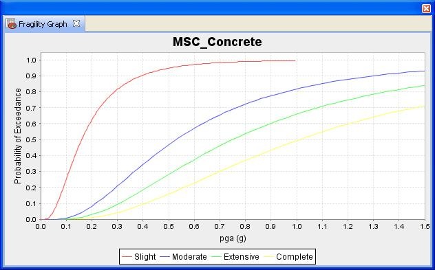
If you right-click a fragility dataset from the Catalog View, you can select View Fragility to access the Fragility View. The Fragility View shows a list of fragility types that you can drill down into to select and view a particular fragility curve. When you have found the fragility curve that you want to view, right-click it and select View Fragility Set to view a graph of the fragility curve. See the image below.
MAEviz Tutorial
The tutorial covers the typical steps that will be needed in order to perform an earthquake risk assessment. Here are the steps:
- Create a New Scenario
- View the Scenario and Add Data
- Running an Analysis
- Analyzing the Results
Example Scenario
In this demonstration, we will use MAEviz as a specific stakeholder would use the tool. The South Carolina DOT has contracted with your group to perform a seismic risk assessment of the transportation network in Charleston South Carolina. Using recently developed bridge fragility curves, and damage-functionality relationships for bridges, you are to perform an analysis of the approximately 340 bridges in the region. The bridge fragility curves are developed for 9 classes of bridges, which cover over 90 percent of the bridge inventory in Charleston. The Hazard which will be evaluated is a magnitude 7.3 earthquake near Charleston (Summerville).
In the process, we will see how the Emergency Manager will launch the MAEviz application, load the GIS data for Charleston County, and then generate earthquake hazard information based on the scenario he wants to investigate. After he has loaded this base information, he can interactively choose and display information for the specific items he wants to evaluate - the bridges, as well as load fragility information about these particular structures. From there, we will witness an analysis of the impact of the hazard. This analysis will assist the stakeholder in evaluating the impact of the damage to the transportation network and consequently, emergency routes. These factors have important social and economic impacts.
Creating a New Scenario
- When you start MAEviz and if this is the first time you have run MAEviz, you will be shown the welcome screen. To begin working with MAEviz, click the rightmost icon ( ) which will take you directly to the MAEviz workbench.
- From the application's menu bar, click File -> New Scenario. Alternatively, you can click the New Scenario button ( ) from the Scenario View's tool bar
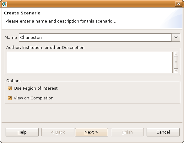
- The New Scenario Wizard will now be showing. This is where you define the scenario that you would like to work with. Enter a name for your scenario, such as "Charleston", and then optionally enter any descriptive information about the scenario in the large text box. Click the Next button. See the figure below.
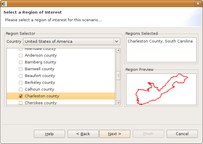
- At this point, you will be selecting the region of interest that you would like to work with. We will be analyzing Charleston, SC, so select United States of America from the Country menu. You should see a list of states appear in alphabetical order. Scroll down to find the state of Tennessee and click the
symbol next to South Carolina. You will now see a list of counties displayed. Scroll down to find Charleston and click the box so that a check appears next to the name. You should now see Charleston, South Carolina populate the Regions Selected box. This new region of interest wizard allows you to add multiple regions of interest by checking other boxes of regions you want to use; however, for this tutorial we will only focus on Charleston (See figure below). Click Next when finished.
- The next screen allows you to select a default set. This will populate the analysis user interface pages with default data where applicable (e.g. default fragilities, default fragility mapping, etc). From the dropdown menu, select MAEviz 3.0 South Carolina Defaults. Note: For completeness, this tutorial will assume that no default set has been chosen so you might find some fields that you are requested to fill in already filled in for you. In these cases, you can ignore the tutorial instructions. Click Finish to complete the wizard and have MAEviz initialize your new scenario.
Viewing the Scenario and Adding Data
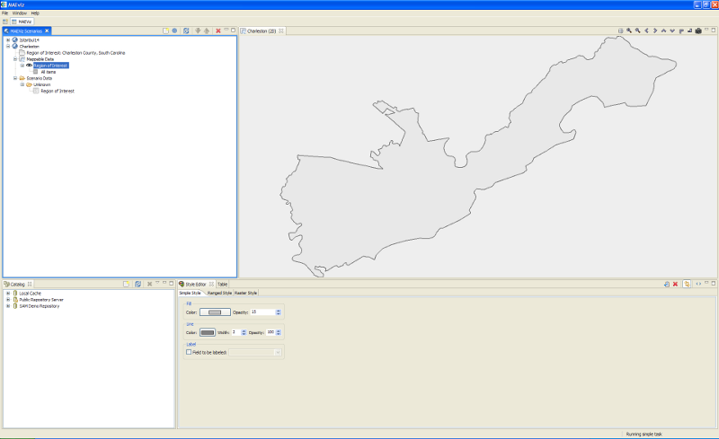
At this point, your scenario has been created. You will see your scenario listed in the Scenario View and a blank outline of Charleston County has appeared in the Visualization View. See figure below.
At this point, we will learn how to add data to our scenario, and how to manipulate the Visualization View.
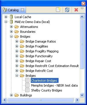
- First, we will add bridge data to the scenario. In the Catalog view (the lower-left view if your workbench is arranged in the default setting, as shown in the figure below), expand the MAEviz Demo Data item, then Bridges, Bridges, then select the bridge dataset for our study area, Charleston Bridges. Click and drag the Bridge datasets into the Visualization View. Alternatively, you can right-click the item and select Load Dataset.
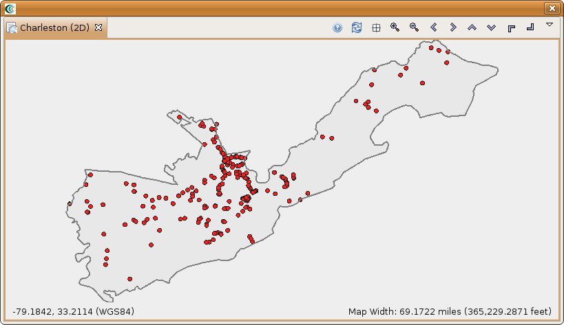
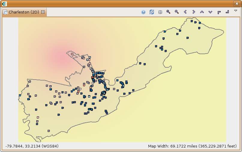
- At this point, bridges of the Charleston County should have been added to the Visualization View, and your Visualization View should look something like the figure below.
Some visualization controls:
- To zoom/pan/etc, use the controls at the top of the Visualization View.
- To view a 3d rendered view of the same information, right click the entry for your Scenario, and choose Render in 3D (VTK). This will bring up a second Visualization View that shows the same map, but from a 3d rendered perspective.
- After adjusting your view, if you want to restore to the original default view in the Visualization, click the Zoom to full extent button in the toolbar ( )
Running an Analysis
Now that we have a basic map to look at, we will learn how to run an analysis. Analyses in MAEviz consist of any calculation that generate data. For example, generating a deterministic earthquake map based on a moment magnitude and epicenter would be considered one type of analysis. Using that earthquake map as well as bridge inventory data to generate information about bridge damage would be another type of analysis.
In this example, we want to find bridge damage results based on a deterministic earthquake hazard that we will generate.
- First, we will launch the Run Analysis Wizard. To do so, either click the Execute Analysis toolbar button ( ), or right click your scenario and select Execute Analysis.
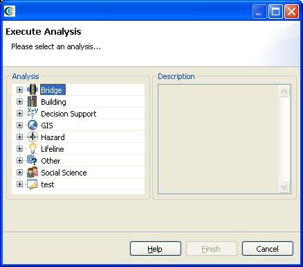
- This causes the Run Analysis Wizard to be shown. See Figure below. Here you can select which analysis you want to run. From this page, expand Bridges, and select the Damage analysis. Click Finish.
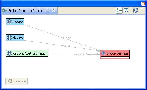
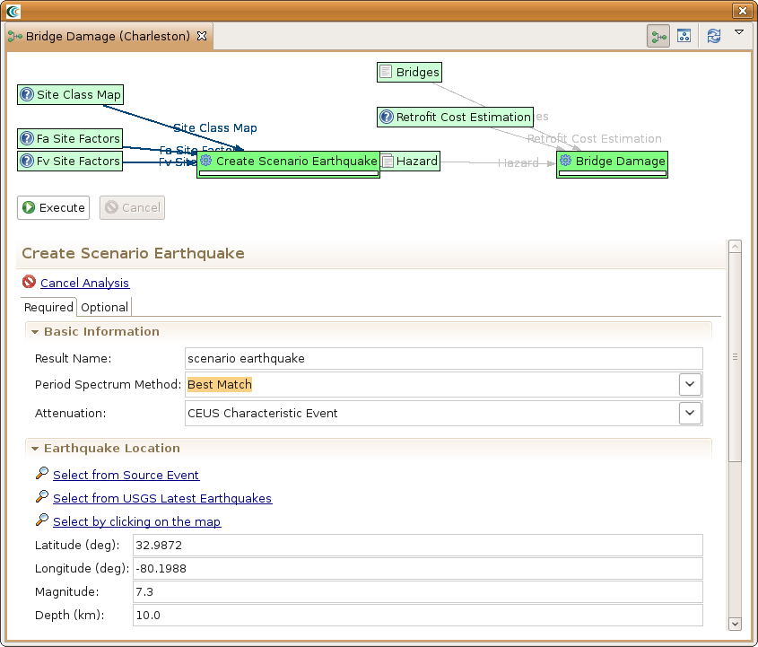
- The page that displays will show you a graphical view of the damage analysis, including all of its inputs and the current readiness of the analysis. See the figure below. If the graph does not look as well spaced as the one below, you can use the refresh button ( ) to improve the graph view. It might also be necessary to enlarge the graph view if more space is required.
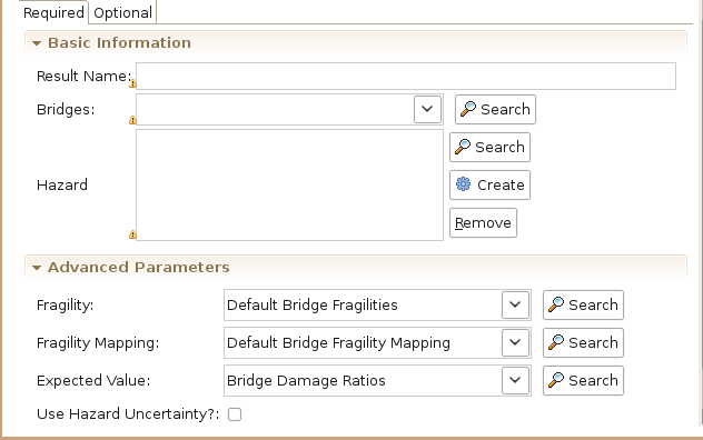
- The red background of Bridge Damage indicates that not all required inputs have been set. To begin, click once on the Bridge Damage box in the graph and an input form should appear below the analysis graph. See figure below. Under the required tab of the form, you will need to provide several inputs. Since we have a default set loaded, the form has several filled in fields and the next instructions will probably not apply to your scenario, but might be good to review. Otherwise, we would have to load datasets containing Fragilities, Fragility Mapping, and Expected Value into the scenario. To run this analysis, you must load datasets that contain these data if they are not already filled in. Also, select the bridges that we loaded from the Bridge drop-down menu and enter a name for the resulting dataset in the result name field (e.g. Bridge Damage).
- To help you locate or generate the necessary input data that we don't have in our scenario, the Analysis Form provides two types of buttons, the Find Dataset button ( Search), and the Generate Dataset from Analysis button ( Create)
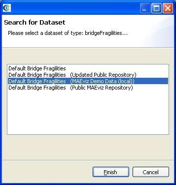
- To find a Fragilities dataset to run your bridge damage with, click the Find Dataset button ( ). The window that appears contains a list box of all Fragilities Datasets that could be found in any of the data repositories that you are connected to. Select Default Bridge Fragilities from the list, and click Finish. See figure below. To find an Expected Value dataset follow the same steps for the related field and select Bridge Damage Ratios from the list, and click Finish. Follow the same steps for the Fragility Mapping dataset but select Default Bridge Fragility Mapping from the list.
- For our hazard, we want to create a deterministic earthquake hazard. So this time, use the Create button to add a scenario earthquake analysis node to the graph. Click on the Create Scenario Earthquake box and you should see a form similar to the bridge damage analysis form. You will need to fill in a result name and select CEUS Characteristic event for the Attenuation. Under Earthquake Location, enter 32.9872 for latitude, -80.1988 for longitude, 7.3 for magnitude and 10.0 for depth. The rest can be left with the default values. See figure below.
- After doing this, both the Create Scenario Earthquake box and the Bridge Damage box should have turned green. Click the Execute button. Alternatively, we could have clicked the optional tab on the bridge damage analysis form and selected to apply some retrofits. By default, MAEviz will use the as-built fragility for each bridge unless we specify to use retrofit fragilities in the optional tab. Once the progress bars have finished for each analysis, you should see new datasets added to your Scenario View and map: a Bridge Damage dataset which will contain the damage information, and the earthquake hazard dataset. Your Visualization should now look similar to the figure below with the bridges colored by mean damage.
- Next, you can execute Functionality, Retrofit Cost Estimation , Damage (using retrofits), Repair Cost and Cost Benefit Analysis using similar steps as we just used for the Damage analysis. For the Bridge Functionality Analysis follow the same steps you did for Bridge Damage. You may want to give the functionality result a descriptive name, such as bridge functionality ab, the "ab" standing for as-built.
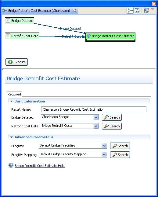
- To run the bridge retrofit cost estimation analysis, first, we will launch the Run Analysis Wizard. To do so, either click the Execute Analysis toolbar button ( ), or right click your scenario and select Execute Analysis. Then, select the Retrofit Cost Estimation Analysis under the Bridge category. You should see a similar window to the one in the figure below. Enter a descriptive name, such as Charleston Bridge Retrofit Cost Estimation, and then click Execute.
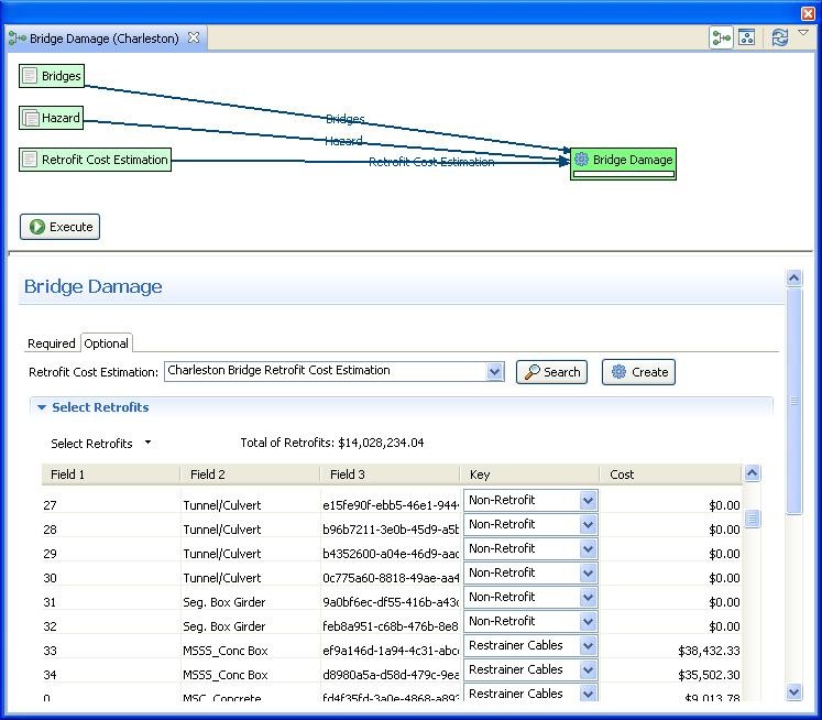
- To compute the bridge retrofit damage, first, we will launch the Run Analysis Wizard again. Then, select the Damage analysis under the Bridge category. Enter a descriptive name, such as Charleston Retrofitted Bridge Damages. After filling in the information under the Required tab (use the same options as you did under the bridge damage analysis, except now you can search for the scenario earthquake we created), select the Optional tab since we will now need to make some additional selections in order to get the damage after retrofitting. Where it says Retrofit Cost Estimation, select the retrofit cost estimation dataset we just created and you should see the form populate retrofit selection fields. In the Select Retrofits menu on the form page select the setAllTo option. From the dialog that comes up, set all bridges to use the Restrainer Cables retrofit and click OK. Your form should look similar to the one in the figure below. Click Execute.
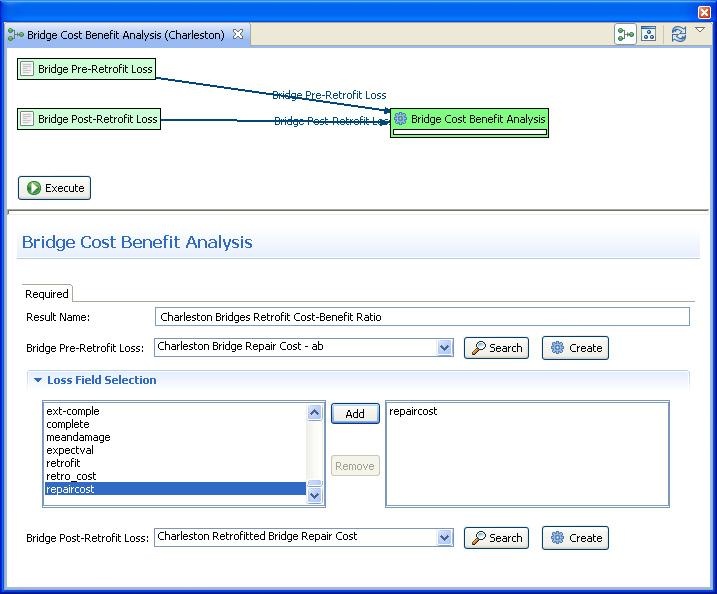
The last analysis type we will demonstrate for the bridges is the Cost Benefit Analysis. This analysis requires the Pre- and Post-Retrofit Losses, which are the results of previous two steps. Select the appropriate datasets for these fields like (see figure below) and enter a descriptive name such as Charleston Bridges Retrofit Cost-Benefit Ratio. Once the datasets have been selected, you can select the fields we want to compare for the cost benefit. Scroll down and find the repaircost field and click the Add button. The analysis should now be ready to run so click the Execute button.
Analyzing Results
Now that the analyses that we were interested in have been completed, it's time to analyze and try to make sense of the results. There are various ways of viewing and visualizing the results, which we will learn now.
- First, we will view the results in a tabular grid, similar to an MS Excel spreadsheet. In the Scenario View, right click on the Bridge Damage layer, and select Show Attribute Table. The Table View should appear in the bottom right of the application window. Like other windows, you can move or resize it to make it easier to view.
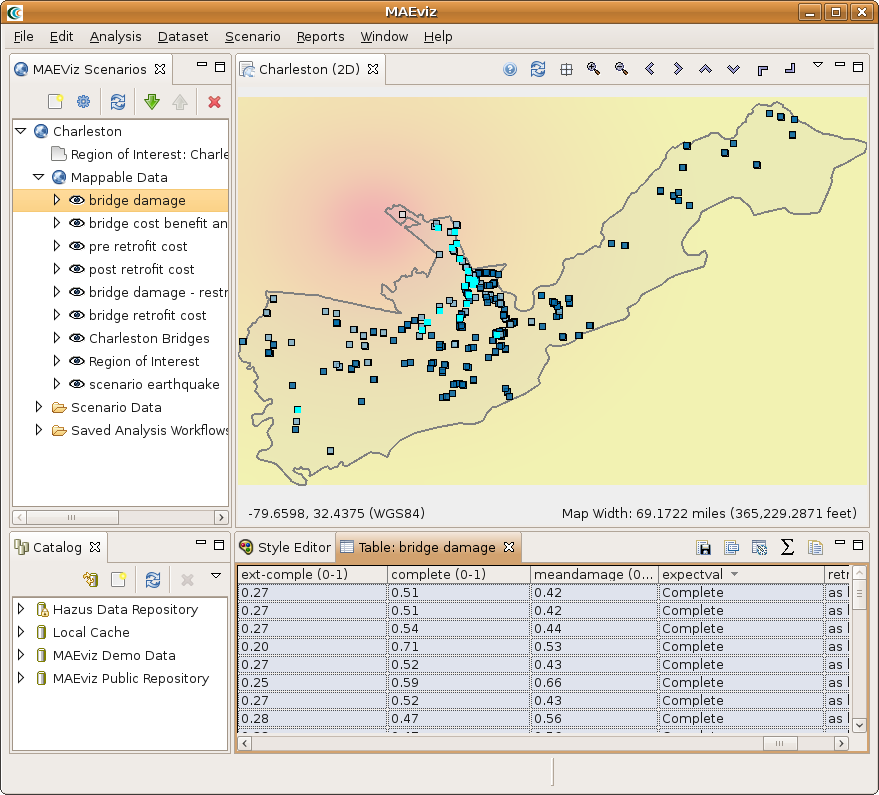
- Now we will use the Table View to locate the bridges that suffered the most damage. Scroll to the right edge of the table view, and click the column header labeled expectval, which is the column for the expected damage value for the bridge. This will sort the table by the expected damage value.
- Now that we can see which bridges in the table have an expected value of Complete damage, let's locate those bridges in our map of the area. Make sure the Bridge Damage layer is still selected in the Scenario View, and make sure you are viewing the 2D Visualization View.
- Then, in the Table View, click on the first row with expected Value of Complete. You will one of the dots representing a bridge in the Visualization View change color to show that this is the selected bridge. The highlighted bridge will be colored light blue.
- Hold shift and click the last row with Complete as the expected value. This will select all the bridges in between. You will see these bridges highlighted light blue in the Visualization View. This way, you can see which bridges will likely suffer the most damage. See figure below.
3D Damage Bars
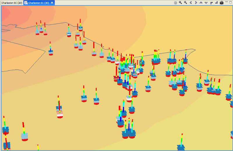
- Next, let's add 3d damage bars to the bridges to make it easier to visualize damage across the entire map. Right click the Bridge Damage layer in the Scenario View, and choose Ranged 3D Visualization....
- Now we can choose which fields we want to display 3D damage bars for. For this example, we will want to see the chance of each damage state, so select none, slight-mod, mod-extens, ext-comple, and complete. Click Next. We will need to select some colors to distinguish between the damage states so you can either use the default or make some new selections. Click Finish and see the figure below.
Filtering Data
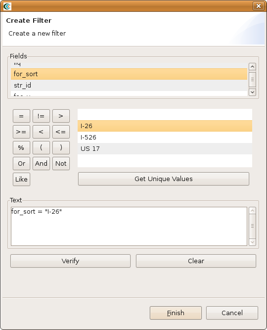
- Now let's look at just those bridges along Interstate 26 (I-26). Right click the Bridge Damage layer, and select Filter. This brings up the Create Filter dialog box.
- In the Create Filter dialog, you must pick a field and value to filter by. Find and double-click FOR_SORT from the fields box at the top. This adds this field to the query at the bottom in the Text field. Click the = button to add an equal sign to the Text field because we want to find a particular value in the bridge damage dataset.
- Click the Get Unique Values button to see all possible values from that column in the building damage dataset. Find and double-click I-26. The dialog should look like the figure below.
- Press the Finish button. When it has finished filtering the dataset, you should see that many of the damage bars have been removed. This is because it is only displaying the damage bars for bridges along I-26.
Reporting
- Now we have finished generating some data and looking at the results through some visualization tools and the table view, we will now generate a printable report. Right click the name of your Scenario in the Scenario View, and select the Reports option. This will open the Select Report View where you will see a list of reports that MAEviz can generate. The default reports for MAEviz are the Default Detail Report and Default Summary Report which are generated from the metadata defined for each result type.
- In this tutorial, we only want a summary of the bridge damage, so we'll use the Default Summary Report. If we wanted a detailed report of all the bridges, we could use the Default Detail Report which would provide details about the damage for each bridge.
- To run the Summary report for bridge damage, double click the Default Summary Report entry in the list. This should bring up the Select Datasets dialog. Select the bridge damage dataset and click the Finish button. It may take a few minutes to run the report, but when it is finished a PDF report should open with the bridge damage summarized similar to the figure below.
- You save the report by going to the File menu and select Save a Copy. This will save the report in PDF format.
- You can print the report by going to the File menu and select Print.
Decision Support
In this section, we are going to demonstrate the Network-based Seismic Retrofit (NBSR) Analysis, one of the advanced features included in MAEviz. Given a particular budget constraint, MAEviz will recommend a retrofit strategy for the set of bridges to minimize the change in total system travel time (TSTT). Similar to the building decision support, we are going to need more data in order to effectively use the decision support tools. We don't have all of the data for running the Charleston bridges as an example so we are going to switch gears and build a new scenario with Shelby County Tennessee as our region of interest. You will need to follow the previous steps for creating a new scenario with the following changes:
- Choose Shelby County, Tennessee as the region of interest
- For the default set, choose MAEviz 3.1.1 Analysis Defaults
After setting up the region, we will go straight to the NBSR analysis and use it to find our datasets.
- Bring up the execute analysis wizard, expand Decision Support and select Network Based Seismic Retrofit Analysis. Click Finish
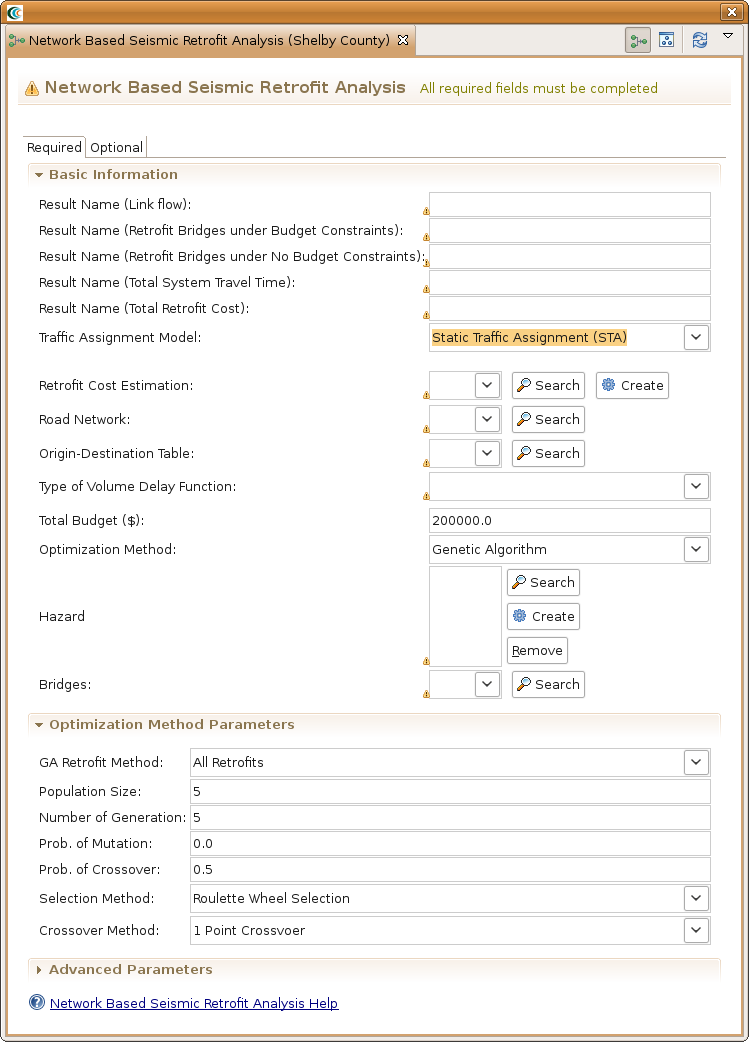
- In the analysis graph, click on the Network Based Seismic Retrofit Analysis box to bring up the analysis form page. You should now see a form page similar to the one below with mostly blank fields.
- For the Result Name (Link flow) field, provide a name such as Shelby County Link Flow Result
- For the Result Name (Retrofit Bridges under Budget Constraints) field, provide a name such as Bridge Retrofit - Constrained to Budget
- For the Result Name (Retrofit Bridge under No Budget Constraints), provide a name such as Bridge Retrofit - Not Constrained to Budget
- For the Result Name (Total System Travel Time) field, provide a name such as Result - Total System Travel Time
- For the Result Name (Total Retrofit Cost) field, provide a name such as Result - Total Retrofit Cost
- For the Traffic Assignment Model, select Static Traffic Assignment (STA)
- For Bridges, click the Search button ( ) and find Memphis bridges - NBSR test data.
- For Retrofit Cost Estimation, click the Create button. This should add a new analysis to the analysis graph. Click on the Retrofit Cost Estimation box to bring up the form page.
- For the Result Name field, provide a name such as Bridge Retrofit Cost Estimate.
- For the Bridge Dataset field, select the bridges we previously loaded, Memphis bridges - NBSR test data. If you haven't already loaded them, click the Search button ( ) to find them in the MAEviz Public Repository. Now, go back to the NBSR form page.
- For the Road Network field, click the Search button ( ) and find the dataset memphis new road for nbsr in the MAEviz Public Repository.
- For the Origin-Destination Table, click the Search button ( ) and find the dataset memphis od for nbsr test.
- For the Type of Volume Delay Function field, select BPR Function.
- For the Total Budget field, select $2M.
- For the Optimization Method field, select Genetic Algorithm.
- For the Hazard field, click the Create button to add the Create Scenario Earthquake box to the analysis graph. Click on Create Scenario Earthquake to bring up its form page.
- For Result Name, provide a name such as Memphis 7.3 Scenario Earthquake
- For the Magnitude field, enter 7.3. The rest can be left as is. Click on the NBSR box to go back to the NBSR form page.
- For all other fields, the default values filled in by the Default Set are fine, all of the analysis boxes should now be green indicating the analysis is ready to go. Click the Execute button.
Network Loss
This advanced analysis in MAEviz determines the resulting link flow from a damaged network.
Conclusion
Based on this simple bridge damage analysis, we can conclude that the MAEviz tool helps to identify areas of high risk. MAEviz could also have been used to look at some mitigation options that may be beneficial to consider. The Emergency Manager in our example is able to take the information and results from this analysis and evaluate detailed options for specific bridges based on proprietary information in the department's databases and files. Furthermore, probabilistic scenarios can also be evaluated in addition to a deterministic earthquake such as the one we used in this example to provide for a wider range of events instead of one specific event. The analysis could also be expanded to look at other components in the region such as the utility networks, schools (since these typically serve as temporary shelters), hospitals, police stations, etc. Some of these data are available with the default installation of MAEviz and is left as an exercise to the user.
The MAEviz tool provides an environment for visual exploration, analysis and evaluation of engineering options pertinent to investigating bridge and building retrofit options. There are more advanced analyses such as decision support for both bridges and buildings that can help users determine retrofit options and pre- and post-disaster planning. Furthermore, the MAEviz Cyberenvironment provides the ability to collaborate and share results with other MAEviz users.
Please contact the Mid-America Earthquake Center for further information on MAEviz.
Mid-America Earthquake Center
205 N. Mathews Avenue
1240 Newmark Lab
Urbana, IL 61801
Tel: (217) 244-6302 Fax: (217) 333-3821
