...
OpenLayers is an open source Javascript library for delivering dynamic map content to any web page. It can display map tiles and markers loaded from any source and is supported by the open source community. By abstracting out the server side and setting up a common interface between the client and the server side, any map service or custom coded library can provided content and functionality to the client removing the limitation of waiting for the commercial vender to provide new features and bug fixes. User interaction will also be improved since the clients have more control over rendering and visualization; however, some of the advanced rendering capabilities provided by ArcIMS would have to be custom coded and there will be more computational load on the client. This increased computational load is partially mitigated by the increasing computational power available to common users.
!mm_arch_new.jpg!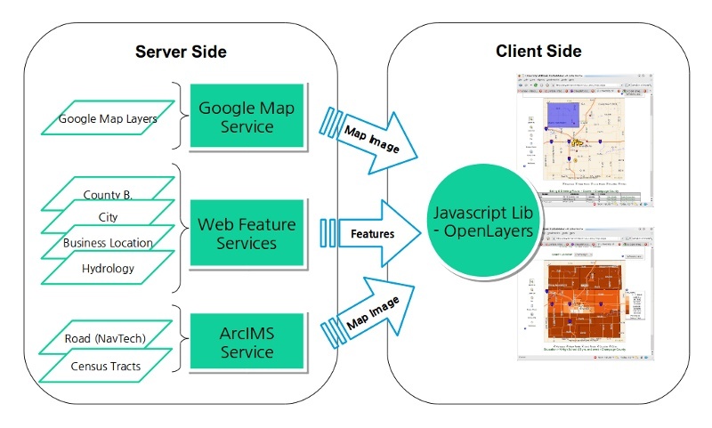
Figure 2. Proposed Architecture
...
The map component will use the PostgreSQL database with the PostGIS spatial database extension, which provides support for geographic objects, spatial indices, and many common spatial operations that will improve the performance and scalability of the map component and provide advanced query capabilities. PostGIS is free and open source and follows OGC-standard geometry types such as well-known-text (WKT) and well-known-binary (WKB) and OGC-standard spatial operations such as intersect, union, overlap, etc. This will make importing and manipulating data easier. In addition, the PostGIS spatial database is a widely used open source project that is compatible with numerous GIS applications and libraries (e.g. GeoTools, MapServer, Grass, etc).
Deliverables
By the end of the grant period the team will deliver a software package containing the above described functionality, including relevant source code. In addition to the package itself, help documentation and tutorials for executing the software will be delivered. For a time period of at least until the grant period ends, the team will provide additional online resources: a source code repository containing the latest source code, a publicly available bug tracking system, a daily build server containing the most recent builds, a web site containing up to date links to resources, and a publicly available data repository containing the appropriate sample datasets.
The team will also deliver a set of virtual machines configured as follows:
- A virtual machine configured to run the PostGIS database as described above.
- A virtual machine configured to run a web server with the web mapping component described above.
These virtual machines will be properly tested and configured to perform the tasks described in this document.
The component will consist of three major components:
- Map
- Query Builder
- Search Results Table as shown in Figure 3.
Map
This component will be implemented by using OpenLayers toolkit and will display the selected map layers overlaid. For this project, we will support at least two layers extracted from the current Market Maker database, Illinois census tracts and Illinois business locations. In addition, background layers from Google Maps will also be supported. The map component will show detailed information for each geospatial entity by clicking on or hovering the mouse over the entity. A map legend and navigation bar will also be provided.
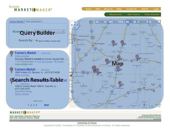
Figure 3. Mock-up user interface and major parts
Query Builder
Users will use the query builder to define and refine their criteria for the information they want to be displayed on the map and table (or list). As the user changes their criteria, the other components will be updated automatically.
Search Results Table
The results from the query builder will also be displayed in a search results table. This will provide a concise view of the result of the query.